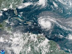
Is Hurricane Erin the Next Category Five Threat?

Understanding Hurricane Erin: A Category Five Storm and Its Implications
As Hurricane Erin has rapidly intensified into a formidable category five hurricane, it raises critical questions about preparedness, response, and the future of hurricane patterns in a changing climate. With maximum sustained winds reaching 160 mph (260 km/h), the storm has been labeled as "extremely powerful" by National Hurricane Center Director Mike Brennan. The phenomenon of rapid intensification, where a storm strengthens by at least 34 mph in 24 hours, is a key factor that demands our attention. This article will delve into the implications of Hurricane Erin, its projected path, and the growing concerns related to hurricane activity in the Atlantic.
The Current State of Hurricane Erin
Hurricane Erin's rapid escalation from a tropical storm to a category five hurricane within a short period is alarming and indicative of changing weather patterns. As of now, the storm is expected to pass north of several Caribbean islands, including the Leeward Islands, the Virgin Islands, and Puerto Rico over the weekend. Residents in these areas should prepare for the potential of up to 6 inches (15 cm) of rain, which could lead to flash flooding and mudslides.
Despite the high intensity of Hurricane Erin, current forecasts indicate that it is not projected to make landfall on the mainland United States. However, this does not diminish the storm's potential impact on coastal regions, especially as it gradually moves northward toward the Bahamas and the Outer Banks of North Carolina next week.
Impacts of Hurricane Erin
The repercussions of Hurricane Erin extend beyond its immediate wind speeds. Here are some potential impacts to consider:
- Heavy Rainfall: Areas in the storm's path can expect significant rainfall that may lead to flash flooding.
- Dangerous Surf Conditions: The storm will generate hazardous surf and rip currents along almost the entire east coast of the United States.
- Life-Threatening Conditions: Regions such as Florida and the mid-Atlantic states may experience the most severe surf conditions, with Bermuda also facing risks from heavy rainfall and surf.
Warnings and Preparedness
The US Coast Guard has issued warnings regarding gale-force winds expected within the next 24 hours, which have led to restrictions for vessels in ports on St. Thomas and St. John in the US Virgin Islands. Additionally, six municipalities in Puerto Rico, including San Juan, are advised to remain vigilant as the storm approaches.
Residents in the affected areas should take the following precautions:
- Stay informed by monitoring local news and weather updates.
- Prepare an emergency kit with essentials such as food, water, medications, and important documents.
- Follow evacuation orders from local authorities if necessary.
- Secure your property by bringing in outdoor furniture and securing windows and doors.
The Science Behind Rapid Intensification
Rapid intensification is a phenomenon that meteorologists are increasingly concerned about. It refers to a storm's ability to strengthen quickly, sometimes dramatically, in a short time frame. This can occur due to several factors, including warm ocean waters, low wind shear, and favorable atmospheric conditions.
In the case of Hurricane Erin, the storm underwent a remarkable transformation, intensifying from 100 mph to 160 mph in a matter of hours. This rapid change highlights the importance of monitoring and understanding the conditions that facilitate such intensification.
Climate Change and Hurricane Frequency
The National Oceanic and Atmospheric Administration (NOAA) has predicted an "above-normal" Atlantic hurricane season this year. There is growing evidence suggesting that climate change is contributing to an increase in the frequency and intensity of tropical storms and hurricanes.
Warmer ocean temperatures, a result of global warming, provide more energy to storms, making them more likely to reach category four and five strength. Not only does this pose a threat to coastal communities, but it also raises questions about the sustainability of disaster response and recovery efforts.
Preparing for Future Hurricanes
As Hurricane Erin demonstrates, preparedness is crucial when facing the threat of hurricanes. Here are strategies individuals and communities can implement to enhance their resilience:
- Emergency Planning: Develop a comprehensive emergency plan that includes communication, evacuation routes, and emergency contacts.
- Community Engagement: Participate in local preparedness initiatives to strengthen community resilience.
- Education: Stay informed about hurricane risks and the latest weather forecasts to make informed decisions.
Conclusion: The Future of Hurricanes and Climate Awareness
The rapid intensification of Hurricane Erin serves as a reminder of the challenges posed by increasingly unpredictable weather patterns. As climate change continues to influence hurricane activity, it is vital for individuals, communities, and governments to prioritize preparedness and response measures. The lessons learned from each storm can help shape future strategies for mitigating the impact of hurricanes and ensuring safety for those in vulnerable regions.
As we continue to monitor Hurricane Erin and its effects, consider how you can contribute to hurricane preparedness in your community. Are you ready for the next storm that may come your way?
FAQs about Hurricane Erin
What does it mean when a hurricane rapidly intensifies?
Rapid intensification refers to a hurricane strengthening by at least 34 mph within a 24-hour period. This can significantly increase the storm's potential for damage and impact.
How can I prepare for a hurricane?
To prepare for a hurricane, create an emergency plan, assemble an emergency kit, secure your property, and stay informed about weather updates and evacuation orders.
Is climate change affecting hurricane activity?
Yes, climate change is believed to be contributing to an increase in the frequency and intensity of hurricanes, primarily due to warmer ocean temperatures providing more energy to storms.
As we reflect on the implications of Hurricane Erin, how can we better prepare ourselves and our communities for the storms of the future? #HurricaneErin #ClimateChange #Preparedness
Published: 2025-08-16 16:09:08 | Category: world


