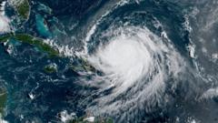
Could Hurricane Erin Impact the UK?

Understanding the Impact of Hurricane Erin on the UK Weather Forecast
As the August Bank Holiday approaches in England, Wales, and Northern Ireland, concerns about Hurricane Erin and its potential impact on the UK weather have surfaced. Currently a Category 4 hurricane, Erin is wreaking havoc on the eastern coast of the United States, generating significant rainfall and dangerous surf conditions. However, the question arises: how will this hurricane affect the weather in the UK? While some media reports suggest a dramatic '600-mile wall of rain,' meteorologists clarify that such predictions are exaggerated. This article delves deep into the anticipated weather patterns, the actual effects of Hurricane Erin, and what to expect as we head into the Bank Holiday weekend.
The Current Situation of Hurricane Erin
Hurricane Erin is making headlines as it strengthens and moves along the eastern seaboard of the United States. Currently, the storm is causing life-threatening conditions with high surf and rip currents expected in the affected areas. As the storm progresses, it is also impacting the southeastern Bahamas and the Turks and Caicos Islands, where a tropical storm warning is active.
Despite its formidable strength, experts assert that Erin is unlikely to make a direct landfall. Instead, the storm will gradually weaken as it travels across the Atlantic. As Simon King, a leading meteorologist, explains, while the remnants of Hurricane Erin may affect the UK weather, the forecasts of a continuous wall of rain are misleading. Rainfall will occur in localized areas rather than in a sweeping, unbroken expanse.
What to Expect in the Coming Week
As we look forward to the Bank Holiday weekend, it’s essential to understand what the forecast indicates. Although the remnants of Hurricane Erin will not significantly affect the UK until after the holiday, meteorologists are predicting a shift in weather conditions. The following week is expected to bring more unsettled weather patterns as the remnants of Erin approach the UK, but specific details remain uncertain.
High Pressure Dominates This Week
For the week leading up to the Bank Holiday, high pressure is likely to dominate the UK weather. This high pressure system will be located to the north-west of the UK, near Iceland, creating a ridge that offers settled and mostly dry weather for most regions. As a result, temperatures will remain relatively warm, particularly in central and western areas.
However, areas of low cloud may form due to low-level moisture, particularly across central and eastern parts of the UK. Fortunately, the August sun should burn off this cloud cover in the afternoons, allowing for more pleasant weather. On Friday, some light showers may develop in northern Scotland, northern England, and possibly Northern Ireland as a shallow area of low pressure develops.
Weekend Weather Outlook
As we transition into the weekend, the forecast remains mostly dry for most areas, particularly as high pressure continues to extend eastward. While some weak weather fronts may attempt to push in from the west, they are expected to fizzle out upon encountering high pressure. Consequently, we can anticipate warmer temperatures, particularly in central and southern England, with highs reaching between 23 and 25 degrees Celsius.
On Saturday, northern Scotland will experience the coolest temperatures of the weekend, ranging between 17 to 19 degrees Celsius. However, the rest of the UK will see temperatures in the high teens to low twenties, providing ideal conditions for outdoor activities, including the widely anticipated Reading and Leeds Festivals taking place over the Bank Holiday weekend.
Bank Holiday Monday Weather Forecast
Looking ahead to Bank Holiday Monday, temperatures are projected to be a degree or so higher than the preceding days, maintaining the trend of warm and pleasant weather across the UK. This sets the stage for a delightful end to the summer season, allowing families and friends to enjoy their time together without the worry of significant rainfall.
Conclusion: What Lies Ahead
In summary, while Hurricane Erin remains a powerful storm causing considerable disruption in the United States, its impact on the UK's weather appears to be minimal for the immediate future. The high-pressure system will keep conditions mostly dry and warm leading up to and throughout the Bank Holiday weekend. However, as we move into next week, the remnants of Erin may bring some unsettled weather, which we will need to monitor closely.
As summer comes to a close, staying informed about local weather forecasts is essential. For the latest updates, consider downloading the BBC Weather app or visiting the BBC website. How do you plan to spend your time during the August Bank Holiday? With warm weather on the horizon, there are plenty of opportunities to make the most of this summer holiday.
FAQs
What is Hurricane Erin currently classified as?
Hurricane Erin is currently classified as a Category 4 hurricane.
Will Hurricane Erin directly hit the UK?
No, Hurricane Erin is not expected to make a direct hit on the UK. Its remnants may affect the weather but will weaken significantly as they cross the Atlantic.
What type of weather should we expect over the August Bank Holiday weekend?
Most areas are expected to experience dry and warm weather with temperatures ranging from the high teens to mid-twenties Celsius.
How will the weather change after the Bank Holiday weekend?
After the Bank Holiday weekend, the remnants of Hurricane Erin may lead to more unsettled weather into the following week, with potential for rain and wind.
As we prepare for the August Bank Holiday, it's clear that while Hurricane Erin poses challenges to the eastern US, the UK is set for a delightful weekend. What activities are you looking forward to during this warm weather? #HurricaneErin #UKWeather #AugustBankHoliday
Published: 2025-08-18 14:42:08 | Category: technology


